Weather Alert in North Carolina
Flood Advisory issued July 9 at 7:49PM EDT until July 9 at 10:45PM EDT by NWS Greenville-Spartanburg SC
AREAS AFFECTED: Davie, NC; Iredell, NC; Rowan, NC
DESCRIPTION: * WHAT...Nuisance to Minor flooding caused by excessive rainfall is expected. * WHERE...A portion of piedmont North Carolina, including the following counties, Davie, Iredell, and Rowan. * WHEN...Until 1045 PM EDT. * IMPACTS...Nuisance to Minor flooding of low-lying areas adjacent to streams and other poor-drainage areas, including farmland, parks, greenways, boat-access areas, golf courses, underpasses, and parking lots. Isolated, shallow flows over roadways is possible. A few flood-prone, low-water crossings may become impassible. A small culvert washout or two is possible. * ADDITIONAL DETAILS... - At 738 PM EDT, Doppler radar and automated rain gauges indicated heavy rain is ongoing due to multiple slow-moving thunderstorm cells extending southwest to northeast from Troutman and Doolie to Mount Ulla, Cleveland, Woodleaf, Cooleemee, Fork Church, and Advance. Between 1 and 2 inches of rain has fallen over the past 45-60 minutes. These cells are training from southwest to northeast over the same areas, prompting concerns for excessive runoff capable of producing areas of nuisance to Minor flooding. Areas of greatest concern include along the headwaters of North Second Creek from Mount Ulla to Woodleaf, including flood-prone low-water crossings at White Rd, Lyerly Rd, Upright Rd, Graham Rd, Hall Rd, Childers Rd, and Bear Poplar Rd. Additionally, areas along Third Creek and associated tributaries, from eastern portions of Statesville and points east, including near Shiloh Rd, Triplett Rd, Third Creek Church Rd, and Carson Rd. Urbanized areas including eastern Stateville and Cleveland may experience deep ponding due to poor drainage. - An additional 2-3 inches of rain is possible over the next 60-90 minutes due to these very slow-moving cells and the movement of additional thunderstorm cells into the Advisory area from the south and west. This rainfall may exacerbate developing flooding or cause new areas of flooding to develop. If these cells persist for an additional 60 minutes or longer, a Flash Flood Warning may be issued. Caution is advised near any stream or other vulnerable area. Seek higher ground immediately if streams start to rise. Please have a plan in place should flash flooding develop and do not hesitate to act. - Some locations that may experience nuisance to Minor flooding include... Salisbury, Statesville, Mocksville, Mooresville, Troutman, Cooleemee, Cleveland, Lake Norman State Park, Woodleaf, Mount Ulla, Fork Church and Advance. - http://www.weather.gov/safety/flood
INSTRUCTION: Turn around, don't drown when encountering flooded roads. Most flood deaths occur in vehicles. Be aware of your surroundings and do not drive on flooded roads. Stay away or be swept away. River banks and culverts can become unstable and unsafe. In hilly terrain there are hundreds of low water crossings which are potentially dangerous in heavy rain. Do not attempt to cross flooded roads. Find an alternate route.
Want more detail? Get the Complete 7 Day and Night Detailed Forecast!
Current U.S. National Radar--Current
The Current National Weather Radar is shown below with a UTC Time (subtract 5 hours from UTC to get Eastern Time).

National Weather Forecast--Current
The Current National Weather Forecast and National Weather Map are shown below.

National Weather Forecast for Tomorrow
Tomorrow National Weather Forecast and Tomorrow National Weather Map are show below.

North America Water Vapor (Moisture)
This map shows recent moisture content over North America. Bright and colored areas show high moisture (ie, clouds); brown indicates very little moisture present; black indicates no moisture.

Weather Topic: What are Shelf Clouds?
Home - Education - Cloud Types - Shelf Clouds
 Next Topic: Sleet
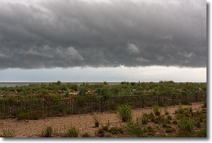
A shelf cloud is similar to a wall cloud, but forms at the front
of a storm cloud, instead of at the rear, where wall clouds form.
A shelf cloud is caused by a series of events set into motion by the advancing
storm; first, cool air settles along the ground where precipitation has just fallen.
As the cool air is brought in, the warmer air is displaced, and rises above it,
because it is less dense. When the warmer air reaches the bottom of the storm cloud,
it begins to cool again, and the resulting condensation is a visible shelf cloud.
Next Topic: Sleet
Weather Topic: What is Snow?
Home - Education - Precipitation - Snow
 Next Topic: Stratocumulus Clouds
Snow is precipitation taking the form of ice crystals. Each ice crystal, or snowflake,
has unique characteristics, but all of them grow in a hexagonal structure.
Snowfall can last for sustained periods of time and result in significant buildup
of snow on the ground.
On the earth's surface, snow starts out light and powdery, but as it begins to melt
it tends to become more granular, producing small bits of ice which have the consistency of
sand. After several cycles of melting and freezing, snow can become very dense
and ice-like, commonly known as snow pack.
Next Topic: Stratocumulus Clouds
Current conditions powered by WeatherAPI.com


